Property Record
250 Meredith Ridge Rd, Athens, GA 30605

NEARBY LISTINGS FOR SALE OR LEASE
Property Detail
250 Meredith Ridge Rd
Athens-Clarke County, GA
Com-St-039->15-25
184-001
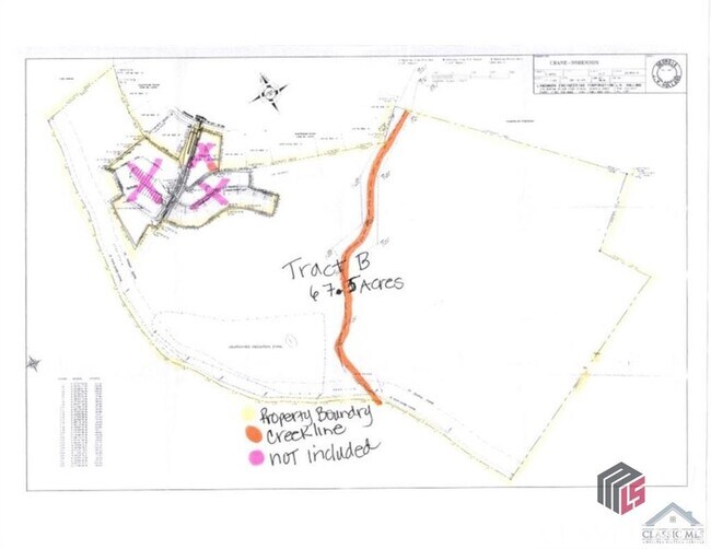
DEEDED ACS: 8.670
Residentialacreage
Clarke
AE
Georgia
13059C0041E
45.61 AC
2025
East Athens
2025
Other Market Areas
150900
DEMOGRAPHICS near 250 Meredith Ridge Rd
1 Mile
3 Mile
5 Mile
2024 Total Population
3,028
32,246
83,139
2029 Population
3,015
32,343
84,432
Pop Growth 2024-2029
(0.43%)
+ 0.30%
+ 1.56%
Average Age
37
35
34
2024 Total Households
1,396
13,901
31,926
HH Growth 2024-2029
(0.36%)
+ 0.29%
+ 1.51%
Median Household Inc
$76,259
$58,081
$52,858
Avg Household Size
2.10
2.20
2.30
2024 Avg HH Vehicles
2.00
2.00
2.00
Median Home Value
$215,116
$235,033
$284,230
Median Year Built
1994
1990
1985
Nearby Places
Map Layers
Map Styles
 Street
 Aerial
- Restaurants
- Banks
- Shops
- Fitness
- Groceries
SALE & LEASE HISTORY
LISTING DATE
SALE/LEASE

Dec 15, 2022
For Sale
Nearby Properties
Address
Land Use
TOTAL SIZE
Lot Size
Zoning
Address
Land Use
TOTAL SIZE
Lot Size
Zoning
47.56 AC
G
Address
Land Use
TOTAL SIZE
Lot Size
Zoning
2,094.97 AC
G
Address
Land Use
TOTAL SIZE
Lot Size
Zoning
300,000 SF
122.56 AC
G
Address
Land Use
TOTAL SIZE
Lot Size
Zoning
56.20 AC
G
Address
Land Use
TOTAL SIZE
Lot Size
Zoning
5.49 AC
G
Address
Land Use
TOTAL SIZE
Lot Size
Zoning
11,600 SF
154.32 AC
AR
Address
Land Use
TOTAL SIZE
Lot Size
Zoning
4,014 SF
19.22 AC
RM-2
Address
Land Use
TOTAL SIZE
Lot Size
Zoning
26.76 AC
G
Address
Land Use
TOTAL SIZE
Lot Size
Zoning
2,062 SF
24.33 AC
RM-1
Address
Land Use
TOTAL SIZE
Lot Size
Zoning
28.91 AC
G
Address
Land Use
TOTAL SIZE
Lot Size
Zoning
3,339 SF
16.80 AC
RM-1
Address
Land Use
TOTAL SIZE
Lot Size
Zoning
74,775 SF
17.95 AC
C-G
Address
Land Use
TOTAL SIZE
Lot Size
Zoning
143,200 SF
19.44 AC
RM-1
Address
Land Use
TOTAL SIZE
Lot Size
Zoning
1,956 SF
93.87 AC
RM-1
Address
Land Use
TOTAL SIZE
Lot Size
Zoning
76.55 AC
RM-1
Address
Land Use
TOTAL SIZE
Lot Size
Zoning
19.92 AC
G
Address
Land Use
TOTAL SIZE
Lot Size
Zoning
3,617 SF
22 AC
RM-1
Address
Land Use
TOTAL SIZE
Lot Size
Zoning
153.94 AC
G
Address
Land Use
TOTAL SIZE
Lot Size
Zoning
452.23 AC
G
Address
Land Use
TOTAL SIZE
Lot Size
Zoning
327.70 AC
G
Address
Land Use
TOTAL SIZE
Lot Size
Zoning
3,339 SF
5.91 AC
C-N
Address
Land Use
TOTAL SIZE
Lot Size
Zoning
47,808 SF
11.08 AC
RM-2
Address
Land Use
TOTAL SIZE
Lot Size
Zoning
12.49 AC
G
Address
Land Use
TOTAL SIZE
Lot Size
Zoning
31.57 AC
G
Address
Land Use
TOTAL SIZE
Lot Size
Zoning
2,509 SF
27.90 AC
RM-1
Address
Land Use
TOTAL SIZE
Lot Size
Zoning
27,918 SF
16.01 AC
RM-1
Address
Land Use
TOTAL SIZE
Lot Size
Zoning
Address
Land Use
TOTAL SIZE
Lot Size
Zoning
11,700 SF
12.05 AC
RM-2
Address
Land Use
TOTAL SIZE
Lot Size
Zoning
15,552 SF
6.84 AC
RM-2
Address
Land Use
TOTAL SIZE
Lot Size
Zoning
28.89 AC
G
The World's #1 Commercial Real Estate Marketplace
Connect with us
© 2025 CoStar Group
The information above has been obtained from sources believed reliable. While we do not doubt its accuracy we have not verified it and make no guarantee, warranty or representation about it. It is your responsibility to independently confirm its accuracy and completeness. Any projections, opinions, assumptions, or estimates used are for example only and do not represent the current or future performance of the property. The value of this transaction to you depends on tax and other factors which should be evaluated by your tax, financial, and legal advisors. You and your advisors should conduct a careful, independent investigation of the property to determine to your satisfaction the suitability of the property for your needs.